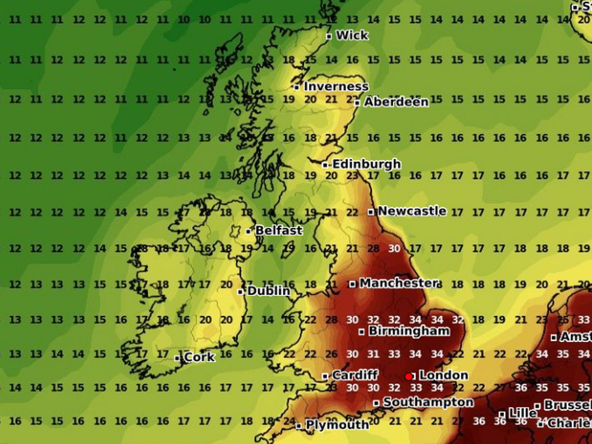
Britain looks set to enjoy heatwave conditions for the second weekend running – with 15 areas set to see temperatures above 32C. Warm weather is expected to build from this afternoon onwards across large swathes of the UK, beginning a three-day hot spell that could see the mercury rise to a sweltering 35C . The UK Health Security Agency has issued amber and yellow heat health alerts which will be in place into the start of next week, and has warned that the hot spell could put extra pressure on NHS hospitals , with higher admissions expected among vulnerable groups. According to forecast maps from WXCharts, the east, southeast and central England will see the warmest temperatures, along with some inland areas of Wales. Conditions are set to stay cooler in Scotland and Northern Ireland, where highs of 18-20C are forecast on Saturday. According to the weather maps, the following 15 regions will be see temperatures above 32C between Saturday and Monday: West Midlands, Leicestershire, Northamptonshire, Bedfordshire, Oxfordshire, Berkshire, Surrey, West Sussex, East Sussex, Lincolnshire, Norfolk, Suffolk, London, Essex, Kent. The Met Office says it expects to declare an official heatwave this weekend in some parts of Britain, bringing us in line with a number of other western European countries. Temperatures could rise as high as 38C in Paris over the next four days, according to the latest forecasts. Mike Silverstone, Deputy Chief Meteorologist at the Met Office , said: “Higher temperatures building over the weekend and into early next week will bring particularly warm, hot or even very hot conditions for some, especially in the southeast and East Anglia and more locally elsewhere in England and east Wales… This in part will be influenced by a heatwave developing across western Europe.” Mike added: “By the weekend, an area of high pressure will be intensifying and dominating the UK forecast. Conditions will be hottest in the south and east while areas further north and northwest will be relatively cooler.” “Monday could see temperatures reach around 34C in some parts, though we will be able to be more precise closer to the time. “The heat is most likely to gradually relent from the west on Tuesday and into Wednesday, with a return towards more average temperatures for the second half of next week.” Remaining cloudy, wet and windy in the northwest Friday. Drier further south and east with sunny intervals, and breezier here than Thursday. Feeling rather warm in the sunshine. Mostly dry through the weekend and start of next week with sunny spells, though some patchy rain possible in the northwest. Turning hot for some, especially across southeastern parts.