By Editor Mark Duell
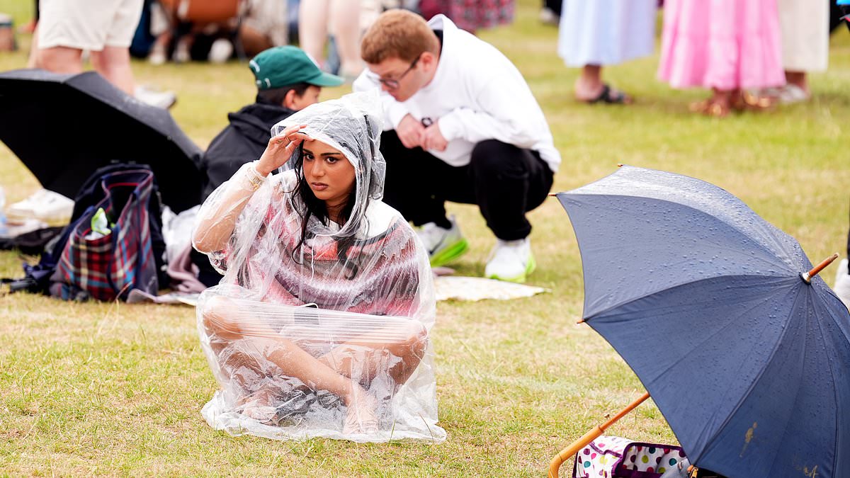
Tennis fans got soaked in the queue for the Wimbledon Championships this morning as Britain’s 35C five-day heatwave finally ended – and was replaced by rain.
Many sweated through another uncomfortable night with thermometers only dropping to 20C (68F) in parts of southern England – but awoke to cooler weather this morning.
While conditions are remaining warm, many places will see a 24-hour temperature difference of nearly 10C today after the UK’s hottest day of the year so far yesterday.
Highs of 25C (77F) are expected today and tomorrow, before a slight increase to 27C (81F) on Friday and then back down to 23C (73F) this weekend.
Wimbledon spectators waiting to get into the site in South West London for day three of the tournament endured a wet start today – although sunny spells will follow later.
Today’s schedule at the All England Club sees British qualifier Oliver Tarvet take on defending champion Carlos Alcaraz on Centre Court while Emma Raducanu and Katie Boulter are among six other British players in second-round action.
It comes after the heatwave peaked yesterday with 34.7C (94.5F) at St James’s Park in London – beating the previous 2025 high of 33.2C (91.8F) on June 21 in Surrey.
The UK Health Security Agency (UKHSA) amber heat health alerts which are in place for much of England warning of a ‘rise in deaths’ will expire at 9am this morning.
But the heatwave gripping continental Europe will last into at least this weekend as a deadly so-called ‘heat dome’ boils countries including Spain, France and Italy.
Today will be a mixed morning in the UK with sunny spells and showery rain which could be heavy in the East – with the odd thundery downpour also possible. Extensive low cloud and coastal mist will also affect much of eastern Britain today.
Conditions will become drier and sunnier later in the afternoon and into the evening, before a fine evening with further spells of sunshine ahead of dusk.
Dry weather is expected for England and Wales tonight with clear skies, but it will be cloudier for Northern Ireland and Scotland with showers spreading eastwards.
Tomorrow will then bring a North-South split, with sunshine and frequent blustery showers across the North but mostly dry with warm sunshine in the South.
Brisk winds and rain will hit the North on Friday, while it will be dry and sunny in the south – although an unsettled weekend is then on the way with blustery showers.
Met Office meteorologist Claire Nasir said: ‘The jet stream is covering most of the UK with fresher weather towards the North West and hanging on to the heat wave across the near continent down towards Iberia as well as central parts of the Mediterranean.
‘Now through the next few days we will see some showers in the mix. In fact, some showers this morning as well, but there will be some fine weather around, particularly across central and southern parts of the country.
‘Through Thursday, a weather front will bring an increasing chance of some showers across Scotland and Northern Ireland with some rain waiting in the wings across the North West as we head through to Friday.’
The hot weather marked the second heatwave for parts of the UK within the last month, with scientists warning the searing temperatures earlier in June were made 100 times more likely because of human-caused climate change.
In Bedfordshire, the council gritters were dispatched to protect the roads and provide grip for drivers amid concerns the heat could cause the tarmac to soften.
Provisional Met Office figures, released yesterday, show England had its warmest June on record last month, while the UK experienced its second warmest since the series began in 1884 – only surpassed by June 2023.
As July kicks off, forecasters said temperatures in the mid-30Cs are still relatively uncommon for the month in the UK, although they are becoming increasingly frequent with climate change.
Conservationists and green experts have also warned of the wildfire risk as well as the impact on farmers, who face another poor harvest following one of the driest springs on record.
In continental Europe, after days of record-breaking heatwaves, some countries will start to get some relief from the Atlantic today – bringing thunderstorms and cooler temperatures.
Paris hit 40C yesterday, but the high will drop to 35C today and to 28C on Thursday, Meteo-France forecast.
Germany’s national weather service is forecasting a peak of 40C today in the economic capital Frankfurt, but that will plummet to 27C by tomorrow.
However, Spain and Italy may have to wait for the weekend to see some limited relief.
Met Office meteorologist Honor Criswick said: ‘It’s likely that we’re now starting to see the peak of the heat, particularly across parts of France.
‘Yes we’re seeing temperatures in the mid to high 30s but it looks like as we head into Wednesday, Thursday, Friday those temperatures are starting to come down but they’re not coming down everywhere.
‘Inland Spain for example, those temperatures are staying fairly consistent still into the weekend and into next week but it’s really across as we head kind of further east.
‘Into the Mediterranean, for example, parts of Italy, once again seeing fairly consistent temperatures over the next few days before potentially maybe a bit of a drop into next week, but still quite a lot of uncertainty around that.
‘So the heat wave looks to be lasting, particularly across parts of Europe, as we head over the next few days and into next week.