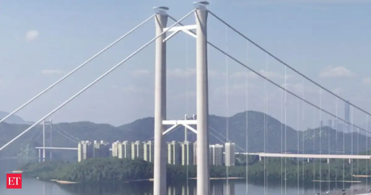
Rendering of the Tsing Lung Bridge, Hong Kong’s first two-way, four-lane bridge, connecting Tsing Lung Tung and North Lantau Island as part of Route 11 infrastructure (Simulated image of the Tsing Lung Bridge)
Tsing Lung Bridge to lead Route 11 infrastructure developmentThe Hong Kong government is accelerating development of the Northern Metropolitan Area through key infrastructure projects, notably Route 11. Spanning approximately 12 kilometers from Lam Tei to North Lantau Island, Route 11 is designated as a strategic trunk road. The Highways Department announced that it will prioritize the Tsing Lung Bridge section of the project, citing its critical role in connecting the Northern Metropolitan Area to the Victoria Harbour Metropolitan Area.According to the department, the goal is to complete technical conditions for bidding on the bridge by 2026, with funding applications submitted to the Legislative Council in 2027. This timeline is intended to allow for simultaneous detailed design and construction work. The department is aiming for the bridge to open by 2033 or earlier.Also read: FWD Group launches US$512 million Hong Kong IPO, targeting HK$48.3 billion valuationThe Tsing Lung Bridge will span approximately 1.3 kilometers and serve as the first two-way, four-lane bridge in Hong Kong. It will connect Tsing Lung Tung on the New Territories side with North Lantau Island, facilitating smoother cross-regional traffic and easing congestion along existing roadways.Design of Tsing Lung Bridge integrates symbolism and functionThe Highways Department highlighted the symbolic architectural design of the Tsing Lung Bridge, noting that it reflects the identity of Hong Kong. The bridge features an “H”-shaped tower representing “Hong” and a “K”-shaped crossbar symbolizing “Kong,” forming a visual representation of “Hong Kong.”Officials stated that this distinctive configuration aims to create a recognizable landmark that integrates into the surrounding natural and urban landscape. The bridge is anticipated to become a popular attraction and a social media check-in destination in the future.Live EventsAlso read: Olympic champion Wang Junxia joins Hong Kong via talent scheme, runs with Lee Lai-shan at Tamar ParkDesigned to serve both practical and aesthetic functions, the bridge incorporates unique structural elements. Its two towers are of unequal height due to specific aviation and maritime considerations, creating an asymmetrical main span. This asymmetry distinguishes it from other regional infrastructure projects.Asymmetrical span meets aviation and maritime constraintsThe Tsing Lung Bridge’s location at the convergence of the Ma Wan Channel, Ha Peng Channel, and Kap Shui Mun Channel imposes strict maritime and aviation requirements. To maintain unimpeded maritime access, the bridge must provide a minimum vertical clearance of 57 meters, equivalent to approximately 20 stories.Simultaneously, airspace constraints related to flight operations at the nearby Hong Kong International Airport at Chek Lap Kok necessitate a height reduction of approximately 55 meters for the bridge tower at the North Lantau end, compared to the tower at the Tsing Lung Tung end.As a result, the design incorporates bridge towers of differing heights and an asymmetrical main span. These features aim to satisfy regulatory requirements while contributing to the structure’s distinctive visual identity.Also read: PwC troubles in China deepen with exit of Hong Kong partnersRoute 11 expected to ease congestion and link economic zonesThe complete Route 11 project will extend about 12 kilometers, passing through areas including So Kwun Wat, Tai Lam Chung, and Tsing Lung Tung. The route will connect with the Lantau Link and the planned Tsing Yi-Lantau Link, providing direct access to Tsing Yi, the broader urban area, and the Central business district via Route 3.The Highways Department stated that most preliminary tasks for Route 11 have been completed. These include environmental assessments, obtaining necessary permits, and satisfying statutory gazette procedures. These advancements authorize the project to proceed to the construction phase.The department emphasized that the Tsing Lung Bridge section will be developed ahead of other parts of Route 11. The intent is to divert traffic from congested roads such as the Sham Tseng section of Tuen Mun Road and the Ting Kau Bridge, improving overall regional connectivity and transport efficiency.(You can now subscribe to our Economic Times WhatsApp channel)
Read More News onTsing Lung BridgeRoute 11 Hong KongNorthern Metropolitan Area infrastructureHong Kong transportation projectscongestion relief Hong Konginfrastructure development Hong Kong
(Catch all the Business News, Breaking News, Budget 2025 Events and Latest News Updates on The Economic Times.) Subscribe to The Economic Times Prime and read the ET ePaper online….moreless
(You can now subscribe to our Economic Times WhatsApp channel)Read More News onTsing Lung BridgeRoute 11 Hong KongNorthern Metropolitan Area infrastructureHong Kong transportation projectscongestion relief Hong Konginfrastructure development Hong Kong(Catch all the Business News, Breaking News, Budget 2025 Events and Latest News Updates on The Economic Times.) Subscribe to The Economic Times Prime and read the ET ePaper online….moreless
Explore More Stories123